
The Mt. Washington Observatory claims that Mt. Washington (the first of the Presidential Range in New Hampshire) has the “worst weather in the world”.
It holds the record for the fastest recorded wind speed in history (231 MPH in 1934). Winds at the summit are at hurricane force one out of every three days. It sees 281 inches of snow per year, on average. The max all time is 566 inches in a single year! Crampons and Ice Axe are absolute necessities.
This evening, after the hike, I happened upon an Outside Magazine article about the 20 Most Dangerous Hikes in the World. Yes, Mt. Washington is very much on that list.
My original plan for New Years Eve was to summit Mt. Marcy in New York. After my slow progress on snowy terrain yesterday, I decided the 18.5 miles with only 9 hours of available daylight was not worth the risk. So I called an audible without must research, and headed to Gorham, New Hampshire to prep for a New Year’s Eve ascent of Mt. Washington.
Some quick research suggested that the Lion Head route was the best, safest (avalanche, etc) and most popular winter route. At 8.8 miles round trip it sounded like a winner!
I did read a few make-you-worried blog posts about the mountain before I went to bed. I didn’t sleep well at all. It sounded like it could be intense and dangerous. Mainly weather. And weather always wins.
When I woke up this morning, I almost considered taking the day off. After some internal debate, I convinced myself to drive over (after some McDonalds breakfast) and see if there were many climbers at the trailhead. Then I convinced myself to set out and hike to the tree line and see how it looked. Then I convinced myself to carry the ridge for a little bit (a chance to use my new crampons and ice axe). Then I convinced myself to keep going. Then I figured the summit must be close. Then I figured it must be really close. Then I figured it must be REALLY REALLY close.
You get the idea.
The Lion Head route gains 4,252 feet of total elevation from trailhead to summit. I am usually a fast hiker. The 4.4 mile “hike” (we’ll get to that shortly) to the top took me from 10AM to 2:15 PM. Roughly 1 mile-per-hour. That gives you an idea of the conditions. The steep terrain. The wind. The deep snow and ice.
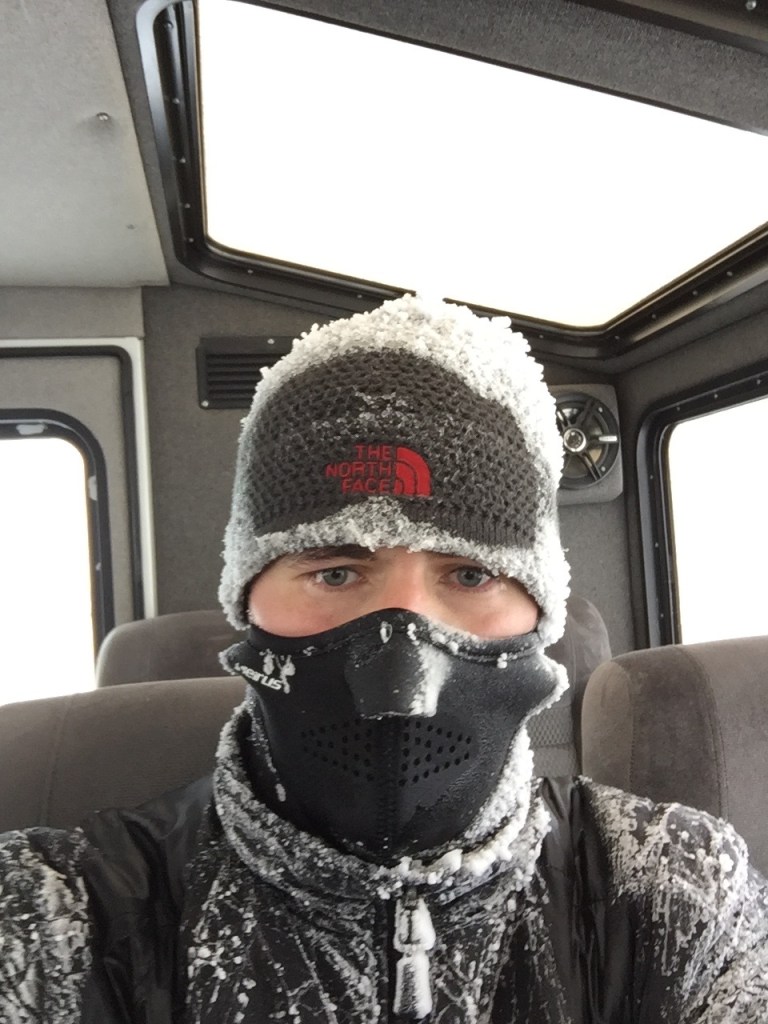
While the weather wasn’t at its worst, it certainly wasn’t sunshine and rainbows.

63 MPH winds. -12 wind chill. These are measurements for the summit, but I suspect that much of the mountain cone and preceding ridge were much the same.
To be honest, I turned around two separate times and decided that living another day and keeping all of my digits was more important than reaching the top. After losing about 400 vertical feet, I happened upon two groups that were also headed up to the summit. They were excited and emphatic that they would make it. I decided I would stick with them and go for it! Why not? I am grateful to these folks (don’t recall names) because I would have been headed back down otherwise. One thing I have learned: you always meet good people on the mountains.
Back to “hiking”. This is no hike. It starts as a hike. A gentle stroll up an eternal hill. Once you break the tree line, the game changes. Visibility diminishes. Crampons are a must to cope with the icy slopes. An ice axe is needed to gain necessary traction and continue to drag yourself upward. All skin must be completely covered to avoid potential frost bite. Each step must be taken with care to ensure the bottom of the ravine does not become an unplanned and permanent destination.
This was, without a doubt, my first excursion into the real world of mountaineering. I have been at far higher elevations in Colorado (>14,000 feet) but the conditions on Washington were far more challenging. While some have referred to it as a Class I, I would say its Class II due to the frequent use of hands (and ice axe).
The Lion Head starts well below tree line, and shares a trail with the Tuckerman Ravine Trail. Its a wide trail. It goes up gradually for roughly 2.5 miles before reaching the Lion Head spur. At that point, the trail quickly becomes very steep. And icy. I was able to navigate the section with microspikes, but crampons would not have been out of the question.
After a few minutes, you reach the tree line and meet the gusting wind. I made a few clothing changes and strapped on my crampons. I traded the trekking poles for the ice axe. Off I went.


The remainder of the trip felt very long and very exhausting. I would estimate 2.5 hours from the tree line to the summit, even though it was only 2 miles. The trail was steep. Snow was deep. Fortunately I was equipped with the necessary gear to travel safely. It was an interesting experience to have to lean over at a 90 degree angle to prevent being blown over backwards down the hill.
Proceeding up the trail, you reach the Lion Head rock outcropping. It was too windy and foggy to enjoy it. All I could think about was the summit, or turning around.
Between Lion Head and the Alpine Garden Junction, you simply follow a long line of cairns. The terrain is steep but not terrible, and the trail is fairly well packed and easy to walk on. From the Alpine Garden Junction to the summit is a very different story.
First, there are snowfields. Fortunately there was no post-holing today. Footing was more challenging though. Slipping and sliding were much more likely. The ice axe came in handy. The wind howled. That was, for me, the most nerve-racking part of the whole endeavor. If there was exposure, I didn’t see it. I made it a goal to make it to each successive cairn. Then I looked for the next. I set a turn-around time of 2pm to ensure I made it back to the car before dark. At 2:05, I was within a few cairns of the summit. So I went for it.
After an unbelievable amount of climbing, I made it! The signs were frozen and unreadable.


My friend Jeff asked me if I was ever scared. That’s a good question. No is the honest answer. I was definitely nervous on several occasions though. Mostly about two things.
First, I was a little nervous about finding my way back down if visibility was poor. For most of today, it was about 30-50 yards. Visibility is at times a function of wind. If wind reached 80-100 mph, it would kick up a lot of snow from the mountainside and fling it into the air, preventing my eyes from seeing what lies ahead. There are cairns (big stacks of rocks) that mark the way to the top, but you can usually only see the next one, or maybe two if you’re lucky. Even when you reach the top you still have to find your way back down a safe route. Since I have had previous experiences getting lost on mountainsides because everything looks the same in the snow, I was worried about the same occurring here.
Second, I was nervous about my toes. I will be the first to admit that I am not an expert at mountaineering yet. I try to do my research and be thoroughly prepared. This trip has taught me that my current boots don’t remain waterproof when exposed to sustained snow. My feet were wet and my toes started to get a little stiff. Frostbite is a real threat in cases where the temperate is low, the windchill is sub-zero, and skin is wet. For my next snow-covered mountaineering adventure, I will be sure to acquire some real mountaineering boots. I was trying to take the low-cost approach by using what I had as good boots are $400-600. However, a few years down the road, I would be happy to pay that to keep all my toes. So new boots are in my future.
I wish I had taken more pictures, but I was set on making it to the top and back down as quickly as possible. It was another day with no views, anyway. I will have to return to New England in the fall sometime in the future and get that part of the experience.
If you are interested in the route, here is a good blog that has a few more pictures and details.
At the end of the trip, everything was coated in thick ice. Including me. 8 hours later, my clothes are still drying.
This trip was worthy of many celebratory beers. Unfortunately, it was hard to find much of anything from New Hampshire. What I found was the Tuckerman Headwall Alt.

It was okay. Not my favorite. I am currently in Burlington, VT. Tomorrow I may summit my 12th peak and final of the trip, or take a rest day. The morning will let us know.
Well, this wraps 2015! I was able to reach the summit of 11 peaks in the United States during that time (all within the last 2 months). It was a quick but great year! Also, congrats to Clemson and Alabama on the big wins tonight!
Happy New Year!

Picture I took on the drive between Mass and New Hampshire.

Sounds like my sleepless night the night before, with many prayers, paid off. What happened to the group you joined to hike to the top?
LikeLike
I got ahead of them and lost visibility. When I started to come back down I couldn’t even see the trail I had come up. I didn’t see any of them. I hope they made it back down without any issues!
LikeLike